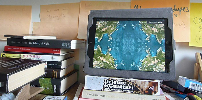
tl;dr: I have made a thing with maps. It is called Rorschmap and you can play with it at rorschmap.com. Also: this page contains weird maps that will likely not play well in RSS or in old browsers.
For a while now, I have been thinking about digital maps. In part, this is the New Aesthetic at play; one aspect of it, the way we see and represent Earth with our new tools. I’ve also been working on another, longer-form map project I can’t talk about yet, but it comes down to something Matthew Knutzen, Geospatial Librarian at the New York Public Library, said to me, something like: “When maps become digital, they become something different, something new”.
That’s it; that’s all, spoken calmly among the stacks of the NYPL’s extraordinary centuries-old, thousands-strong paper map collection. But it’s something we rarely say, about anything digital. We’re so busy looking for ways to make digital books and maps usable in ways that we understand that we fail to do things with them that we don’t understand, or that are beyond our understanding.
Jack Schulze, of BERG, describes this difference in what the map is as animation: a digital map is an animation on pause, redrawn quickly in the browser and slowly in the air, by Landranger aircraft and satellites. Wikistyle maps like Open Street Map redraw the map in time; the plane extends in four dimensions.
It is 65 years since Buckminster Fuller patented the Dymaxion Map, designed to show, and only show, the whole earth. Fuller’s map forced less distortion than contemporary projections; it also, having no ‘right way up’, embodied his idea that the only directions in the universe were ‘in’ and ‘out’.
The plane of Google Maps has an up and a down; it also has an in and an out: the zoom between tile layers, the moment of transference, of refocussing and resolution. What if we could fold digital maps like the dymaxion, go truly into them?

Rorschmap is cartographic navel-gazing, a reframing of the map. It will not help you find anything. We are bored with your squares and your margins. We want new shapes and new dimensions, the unicode snowmen of visual representation. †‡†, as the man said.
The word “kaleidoscope” is derived from the Ancient Greek καλ(ός) (beauty, beautiful), είδο(Ï‚) (form, shape) and -σκόπιο (tool for examination)—hence “observer of beautiful forms”. It was invented by Sir David Brewster in 1815-17. Brewster was also active in the development of the lighthouse; both things were byproducts of his researches into optics. The light, refracted, serves both beauty and safety, both aesthetics and cartography.

Rorschmap should work on most modern browsers. Safari and Chrome are better than Firefox. I don’t know about Windows machines. It is optimised for iPad, and looks rather good there. Enjoy.
Hat tip to the excellent Rob Myers, who put the foursquare dream image into my head, and thanks as ever to Tom Taylor for code advice.
[…] Rorschmap | booktwo.org "Rorschmap is cartographic navel-gazing, a reframing of the map. It will not help you find anything. We are bored with your squares and your margins. We want new shapes and new dimensions, the unicode snowmen of visual representation. †‡†, as the man said." I am wearing out the "James is brilliant" button on my keyboard, but I will keep pressing it as long as he does this sort of thing. (tags: stml jamesbridle maps dymaxion newaesthetic ) […]
Pingback by Infovore » Links for July 29th — July 29, 2011 @ 1:01 pm
[…] is a neat thing with some brainjuice behind it. […]
Pingback by Rorschmap | FYPA.NET — July 29, 2011 @ 10:15 pm
[…] Says Bridle: […]
Pingback by Time-Waster of the Day - The Daily What — July 29, 2011 @ 10:33 pm
[…] של “גוגל ×רץ” ליצירות קליידוסקופיות מרהיבות. במילותיו של ברידל: “Rorschmap ×”×•× ×ª×’×•×‘×” הולמת למפות משעממות. ×× ×—× ×• ×–×§×•×§×™× […]
Pingback by תעלול גוגל ×רץ: להפוך ×ת ×”×¢×•×œ× ×œ×ž×©×—×§ קליידוסקופ | ×—×•×¨×™× ×‘×¨×©×ª — July 30, 2011 @ 9:17 am